|
Oct.
2001 Vol. 222 No. 10
Feature Article
|
EXPLORATION
Tectonic setting of the world’s giant oil fields
Part 2 – A new classification scheme of the
world’s giant fields reveals the regional geology where explorationists may be most likely to find future
giants. In this, the second of a three-part series, seven more areas where giant fields are densely clustered
are presented
Paul Mann and
Lisa Gahagan, Institute for Geophysics, University of Texas at Austin; and Mark B. Gordon, GX
Technology
 lthough
there are large variations in reserve estimates, giant fields contain at least 65% of the world’s proven
reserves.1 Therefore, knowledge of their tectonic setting, geologic history and conditions for
hydrocarbon formation will contribute greatly to understanding the origin and future supply of the world’s
hydrocarbons. The authors discuss how tectonics produced regional clusters of giant fields and their rationale
for classification. lthough
there are large variations in reserve estimates, giant fields contain at least 65% of the world’s proven
reserves.1 Therefore, knowledge of their tectonic setting, geologic history and conditions for
hydrocarbon formation will contribute greatly to understanding the origin and future supply of the world’s
hydrocarbons. The authors discuss how tectonics produced regional clusters of giant fields and their rationale
for classification.
Introduction
A "giant" oil field is defined as one
containing proved reserves exceeding 500 million bbl; a giant gas field contains proved reserves of greater
than 3 Tcf.2 "Reserves" refer to the ultimate recoverable amount and include the amount
produced to date. Some fields are giants only when viewed on a boe basis.3
| |
Legend for the
twenty geological maps
For details, see complete legend in Exxon
Tectonic Map of the World4
Capital letters:
Basin and sub-basin names.
Outcrops:
Color coded by age.
Light to moderate blue:
Offshore areas.
Light to moderate brown:
Total thickness (isopachs in km) of Phanerozoic sediment in basins and platforms.
Shades of purple:
Upper Precambrian to Mississippian.
Blue:
Pennsylvanian to Lower Triassic.
Shades of green:
Middle Triassic to Oligocene.
Yellow:
Miocene to recent. Structures indicated by standard map symbols. |
|
|
 |
| |
| |
Legend for
giant fields
Colors refer to color-coding of the author’s
geologic classification scheme of giants, and are the color of the location number and field on the 20
regional maps.
Light blue:
Continental passive margins fronting major ocean basins. This category is reserved for giants which
are clearly confined to non-rift controlled, passive-margin sections. It is difficult to rule out the
importance of rifts and rift-localized steer’s head basins in passive-margin tectonic settings,
because the level of rifting can become so deeply buried in passive-margin settings that it is
difficult to resolve seismically or reach by drilling.
Blue:
Continental rifts and overlying steer’s head sag basins. Rifts and the overlying, generally
marine, sag basin are key for localizing and forming source rocks in poorly-circulated marine straits
and lakes during the early stages of continental rifting – e. g., Late Jurassic-Early Cretaceous
source rocks of Gulf of Mexico, Fig. 7, and Jurassic source rocks of West Africa, (in Part 2). Such
rifts are either: aborted to form isolated intracontinental rifts surrounded by continental areas like
the North Sea or West Siberian basin, (Part 2); or extended to form passive margins flanking major
ocean basins such as the West African coast. These rifts typically become deeply buried beneath a
carbonate, evaporitic and/or clastic passive-margin section.
Red:
Continental collision margins. These margins produce deep, short-lived basins in interior areas but
broad, wedge-shaped foreland basins in more external parts of the deformed belt where most giants are
found. A popular model in the late 1980s was the "squeegee" model for expulsion of oil from
source rocks shortened and buried in the more interior parts of the deformed belt.15
Macedo and Marshak16 proposed, on
the basis of their inspection of the Map of World Total Oil and Gas Reserves,17 that there
is a spatial correlation between location of foreland-basin oil fields and fold-thrust belt salients,
or places where the fold-thrust belt protrudes or is convex to the foreland. Salient examples
associated with oil fields include Alberta, Wyoming, Santa Cruz (Bolivia), Verkhoyansk (Siberia),
northern Carpathians (Europe), Taiwan, Zagros and Apennines (Italy). In all cases, the greatest
concentration of oil and gas fields is opposite the apex of the salient.
To explain the spatial association, they
speculate that:
- thicker, basinal-sedimentary rocks present
at salients are more likely to yield greater volumes of source and reservoir rocks;
- thicker basinal rocks also produce more fold
culminations, which are likely to act as structural traps; and
- slight along-strike extension at apex areas
could result in increased fracturing that could provide the vertical permeability to permit
migration of oil and gas in association with basinal brines. In contrast to the above concepts,
explorationists in foreland areas like the Persian Gulf have noted that horizontal migration is
small, convergent deformation effects are minimal, and most migration is vertical above deep-seated
source rocks in the rift or passive-margin section.18
Orange:
Arc-continental collision margins. Foreland basins in these settings can sometimes be more narrow and
contain thinner stratigraphic fill than in continent-continent collisional settings, because island
arcs lack the size, crustal thickness and deformation effect of a colliding continent. For example,
many of the circum-Caribbean forelands are narrow for the above reasons and as a result of the oblique
angle of collision between the Caribbean-arc and the continents of North and South American.19
Green:
Strike-slip margins. Strike-slip basins are relatively few in comparison to more common rift, passive
margin and collisional basin types. In general, strike-slip margins form during the later stages of
continental or arc collision as in Anatolia today, or during a ridge-subduction event along a
subduction boundary, as in California. Despite their generally small areal extent relative to foreland
and rift basins, strike-slip basins can contain extremely thick sedimentary sequences, including
excellent source rocks formed during early basinal history. The inherent complexity of strike-slip
boundaries with lateral offsets and structural overprinting probably makes it too difficult to achieve
the ideal combination of source-reservoir and trap needed to make giant fields.
Purple:
Subduction margins. These margins are the least productive for giant fields due to low porosity and
clay-rich sediments common in arc environments. Subduction margins in tropical areas such as those in
southeast Asia can contain carbonate traps. |
|
| |
|
|
North American giant fields (without field outlines)
were digitized from Carmalt and St. John’s published compilation.3 Field locations and
outlines are derived from the Petroconsultants SA, digital database for non-North American giant fields (used
with permission). The 592 giant fields of the world cluster in 20 regions (see
Part 1). Detailed geologic maps of these regions are modified
from the Exxon Tectonic Map of the World.4 Seven of these regions appear in this article; the
remaining six will be discussed in Part 3.
Tectonic Settings
The following descriptions summarize the authors’
rationale for their classification of seven of the 20 areas where giants are concentrated.
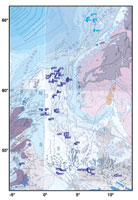
North Sea. The Central Graben is host to 30
giants, Fig. 1. It is a failed rift extending into the Eurasian continental crust. Giants are localized along
the complex normal and strike-slip faults running down the graben axis. The earliest rift phase occurred
during the Carboniferous and Jurassic, with the rift-system trend closely controlled by pre-existing basement
trends. Source rocks were deposited in the initial rift during the Late Paleozoic and Kimmeridgian, with
reservoirs at several levels. An overlying steer’s head sag basin was deposited over the Central Graben
in Late Cretaceous time. Structures were mainly formed during Jurassic rifting, Tertiary magmatism and fault
inversion related to the Alpine collision.
| |
North
Sea |
|
| |
317 |
Gullfaks, Norway, Oil/gas (N. North
Sea) |
|
| |
318 – 9 |
Snorre, Norway, Oil/gas/cnd (N.
North Sea) |
|
| |
320 |
Ekofisk, Norway, Oil/gas/cnd (S.
North Sea) |
|
| |
321 |
Eldfisk, Norway, Oil/gas/cnd (S.
North Sea) |
|
| |
322 |
Statfjord, Norway, Oil/gas/cnd (N.
North Sea) |
|
| |
323 |
Valhall, Norway, Oil/gas/cnd (S.
North Sea) |
|
| |
324 |
Frigg, Norway, Gas/cnd (N. North
Sea) |
|
| |
325 – 6 |
Oseberg, Norway, Oil/gas/cnd (N.
North Sea) |
|
| |
327 – 8 |
Sleipner West, Norway, Gas/cnd (N.
North Sea) |
|
| |
329 |
Draugen, Norway, Oil/gas (Helgeland) |
|
| |
330 |
Heidrun, Norway, Oil/gas/cnd (More) |
|
| |
331 |
Troll West, Norway, Oil/gas/cnd (N.
North Sea) |
|
| |
332 |
Midgard, Norway, Gas/cnd/oil
(Helgeland) |
|
| |
333 |
Smoerbukk, Norway, Gas/cnd/oil
(More) |
|
| |
334 |
Tyra, Denmark, Gas/cnd/oil (S. North
Sea) |
|
| |
335 |
Forties, United Kingdom, Oil (N.
North Sea) |
|
| |
336 |
Claymore, United Kingdom, Oil (N.
North Sea) |
|
| |
337 |
Fulmar, United Kingdom, Oil/gas (S.
North Sea) |
|
| |
338 – 44 |
Scott, United Kingdom, Oil/gas (N.
North Sea) |
|
| |
345 |
Brent, United Kingdom, Oil/gas/cnd
(N. North Sea) |
|
| |
346 |
Beryl, United Kingdom, Oil/gas (N.
North Sea) |
|
| |
347 – 9 |
Cormorant, United Kingdom, Oil/gas
(N. North Sea) |
|
| |
350 |
Piper, United Kingdom, Oil/gas (N.
North Sea) |
|
| |
351 |
Magnus, United Kingdom, Oil/gas/cnd
(N. North Sea) |
|
| |
352 – 3 |
Ninian, United Kingdom, Oil/gas/cnd
(N. North Sea) |
|
| |
354 |
Morecambe South, United Kingdom,
Gas/cnd (Irish) |
|
| |
355 – 6 |
Indefatigable, United Kingdom,
Gas/cnd (S. North Sea) |
|
| |
357 |
Leman, United Kingdom, Gas/cnd (S.
North Sea) |
|
| |
358 – 65 |
Groningen, Netherlands, Gas/cnd (NW
German) |
|
| |
512 |
Salzwedel-Peckensen Germany, Gas (NW
German) |
|
|
|
|
 |
|
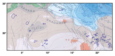
North Africa. These 26 giants can be subdivided
into two regions (Fig. 2): 1) to the west, the Illizi province of Algeria; and 2) to the east, the giants of
Libya’s Sirte rift. Tectonic history of North Africa is marked by convergence during the Paleozoic
Hercynian orogeny, which left a major unconformity separating folded Cambro-Ordovician rocks from unfolded
Permian-Triassic clastic sedimentary and volcanic rocks. During the Pangean breakup, rifts formed across
northern Africa, including the Atlas rift system. Following rifting, the area subsided and received a thick
section of evaporitic and clastic sediments.
During the Late Cretaceous, convergence began between
Africa and Eurasia and resulted in the Alpine mountain chains in northern Africa, including inversion of the
Atlas rift to form the Atlas mountain belt. Giant fields in structural traps occur beneath the Hercynian
unconformity and are sourced by Ordovician and Silurian black shales.
The Sirte basin is a rift basin with a complex
extensional history that began in the late Cretaceous and extended into the Tertiary.5 Source
rocks are Late Cretaceous shales that thicken into the rift basins. Reservoirs comprise reef buildups on
structural highs. Traps are combinations of structural and stratigraphic traps. These giants were classified
as continental rifts with overlying steer’s head basins.
| |
North Africa |
|
| |
1 |
Hassi Messaoud, Algeria, Oil/gas
(Sahara basin) |
|
| |
2 |
Zarzaitine, Algeria, Oil/gas/cnd |
|
| |
3 |
Rhourde El Baguel, Algeria, Oil/gas
(Sahara basin) |
|
| |
4 |
Tin Fouye-Tabankort, Algeria,
Oil/gas/cnd (Illizi basin) |
|
| |
5 |
Taouratine, Algeria, Gas/cnd (Illizi
basin) |
|
| |
6 |
Hassi R’Mel, Algeria,
Gas/cnd/oil (Sahara basin) |
|
| |
7 |
In Amenas Nord, Algeria, Gas/cnd |
|
| |
8 |
Gassi Touil, Algeria, Gas/oil
(Sahara basin) |
|
| |
9 |
Alrar, Algeria, Gas/cnd/oil |
|
| |
10 |
El Borma, Tunisia, Oil/gas/cnd |
|
| |
11 |
Bahi (032-A), Libya, Oil/gas |
|
| |
12 |
Amal(012-B/E/N/R), Libya, Oil/gas |
|
| |
13 |
Beda (047-B), Libya, Oil |
|
| |
14 |
Beda (047-B), Libya, Oil |
|
| |
15 |
Defa (059-B/071-Q), Libya, Oil/gas
|
|
| |
16 |
Defa (059-B/071-Q), Libya, Oil/gas |
|
| |
17 |
Gialo (059-E), Libya, Oil/gas |
|
| |
18 |
Masrab (059-P), Libya, Oil |
|
| |
19 |
Sarir (065-C), Libya, Oil/gas |
|
| |
20 |
Augila-Nafoora (102-D/051-, Libya)
Oil/gas |
|
| |
21 |
Sarir (065-L), Libya, Oil/gas |
|
| |
22 |
Intisar (103-A), Libya, Oil/gas |
|
| |
23 |
Dahra East-Hofra (032-F/Y), Libya,
Oil/gas |
|
| |
24 |
Nasser (006-C/4I/4K), Libya, Oil/gas |
|
| |
25 |
Nasser (006-C/4I/4K), Libya, Oil/gas |
|
| |
26 |
Nasser (006-C/4I/4K), Libya, Oil/gas |
|
| |
27 |
Waha North (059-A), Libya, Oil/gas |
|
| |
28 |
Raguba (020-E), Libya, Oil/gas |
|
| |
29 |
Attahadi (006-FF), Libya, Oil/gas |
|
| |
30 |
Intisar (103-D), Libya, Oil/gas |
|
| |
31 |
Bu Attifel (100-A), Libya,
Oil/gas/cnd |
|
| |
32 |
Messla (065-HH/080-DD), Libya,
Oil/gas |
|
| |
33 |
Hateiba (006-S), Libya, Gas |
|
| |
34 |
Hateiba (006-S), Libya, Gas |
|
| |
35 |
Bouri (NC041-B), Libya, Oil/gas
(Pelagian basin) |
|
| |
67 |
Waha South (059-A), Libya, Oil/gas |
|
|
|
|
 |
|
Fig. 2.
North Africa region. |
|
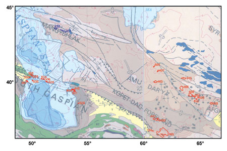
Caspian Sea. In this region (Fig. 3), formation
of giants was initially controlled by a Jurassic rifting event at the northern Tethys margin. Later source
rocks deposited in this rift framework are Paleocene-Eocene. The area’s 26 giant reservoirs are at
various levels within the Cenozoic section, and structural traps formed from the Cenozoic to present-day.8
| |
Caspian Sea |
|
| |
124 |
Khangiran, Iran, Gas/cnd (Turkmen) |
|
| |
368 |
Balakhany-Sanbunchi-Ramany,
Azerbaijan, Oil/gas (Kura) |
|
| |
369 |
Surakhany, Azerbaijan, Oil/gas
(Kura) |
|
| |
431 |
Uzen’, Kazakhstan, Oil/gas
(Middle Caspian) |
|
| |
432 |
Zhetybay, Kazakhstan, Oil/gas/cnd
(Middle Caspian) |
|
| |
443 |
Gazli, Uzbekistan, Gas/cnd/oil
(Kara-Kum) |
|
| |
444 – 45 |
Goturdepe, Turkmenistan, Oil/gas/cnd
(Caspian South) |
|
| |
452 |
Kokdumalak, Uzbekistan, Gas/cnd/oil
(Kara-Kum) |
|
| |
463 |
Kerpichli, Turkmenistan, Gas/cnd
(Kara-Kum) |
|
| |
465 |
Dovletabad-Donmez, Turkmenistan,
Gas/cnd/oil (Turkmen) |
|
| |
468 |
Shurtan Uzbekistan, Gas/cnd
(Tadxhik) |
|
| |
482 |
Urtabulak, Uzbekistan, Gas/cnd/oil
(Kara-Kum) |
|
| |
486 |
Odzhak, Turkmenistan, Gas/cnd
(Kara-Kum) |
|
| |
488 |
Kandym, Uzbekistan, Gas/cnd
(Kara-Kum) |
|
| |
489 |
Dengizkul-Khauzak-Shady, Uzbekistan,
Gas/cnd (Kara-Kum) |
|
| |
49 1 – 92 |
Shatlyk, Turkmenistan, Gas/cnd
(Turkmen) |
|
| |
493 |
Zevardy, Uzbekistan, Gas/cnd
(Kara-Kum) |
|
| |
497 |
Naip, Turkmenistan, Gas/cnd
(Kara-Kum) |
|
| |
501 |
Barsa-Gelmez, Turkmenistan,
Oil/gas/cnd (Caspian South) |
|
| |
503 |
Bibi-Eybat, Azerbaijan, Oil/gas
(Kura) |
|
| |
504 |
Neft Dashlary, Azerbaijan, Oil/gas
(Caspian South) |
|
| |
505 |
Bakhar, Azerbaijan, Gas/cnd/oil
(Kura) |
|
| |
506 |
Guneshli, Azerbaijan, Oil/gas/cnd
(Caspian South) |
|
| |
507 |
Sangacal Deniz-Duvanyy Den,
Azerbaijan, Oil/gas/cnd (Kura) |
|
| |
528 |
Azeri, Azerbaijan, Oil/gas/cnd
(Caspian South) |
|
| |
529 |
Korpedzhe, Turkmenistan, Gas/cnd/oil
(Caspian South) |
|
|
|
|
 |
|
Fig. 3.
Caspian Sea region. |
|
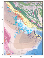
Arabian Peninsula / Persian Gulf. There are 151
giants in this region, Fig. 4. They are concentrated in a large foreland basin formed during the Late Cenozoic
collision of the Arabian Peninsula with Eurasia. Downward flexure of the Arabian Peninsula beneath the Zagros
Mountains of Iran / Iraq was caused by the northeastward consumption of the Tethys Ocean at the Zagros suture
zone. Additional causes of this flexure were the eventual Cretaceous-recent convergence and collision of the
Arabian plate against the Eurasian plate. This protracted convergent event has created the Persian Gulf and
Mesopotanian lowlands as a sag in the foreland basin, as well as formation of the Zagros Mountains, with a
culmination of fold-thrust deformation in Miocene and Pliocene time.
However, other than minor tilting, large areas of the
foreland appear completely undisturbed by Zagros-related convergent deformation, as manifested in the variety
of giant-field shapes. For that reason, formation of elongate giants parallel to folds and thrusts in the
Zagros Mountain and foreland basin was classified as a continental collision margin, while those giants to the
southwest were counted as continental rifts and overlying steer’s head sag basins.
The basal stratigraphic section underlying the
present-day foreland basin was deposited along a Cambrian-Permian passive-margin setting along the southern
Tethys margin. Deeply buried salt, possibly deposited in Cambrian rifts, was activated by small-displacement
basement faults during Permian to Jurassic time. These gave rise to salt ridges and diapirs, forcing folds in
the overlying sedimentary section, which include some of the largest giant fields, such as Ghawar, Saudi
Arabia. These folds are at a high angle to later folds and thrusts related to the Zagros convergence. Source
rocks in this basin phase include Cambrian-to-Permian units, with the main reservoir in the Permian.
A second hydrocarbon-formation period occurred from the
Triassic through Tertiary, with Middle Jurassic source rocks and Upper Jurassic reservoirs. Migration is
primarily upward from underlying source rocks in giant fields that are removed from the Zagros deformation.7
Structural traps formed in the area adjacent to the Zagros foldbelt and relate to early collisional effects in
Eocene and younger time.
| |
Arabian
Penninsula |
|
| |
8 |
Suwaidiyah (Souedie),
Syria, Oil/Gas/cnd |
|
| |
69 |
Zubair, Iraq, Oil/Gas |
|
| |
70 |
Ratawi, Iraq, Oil/Gas |
|
| |
71 |
Bai Hassan, Iraq,
Oil/Gas (Zagros) |
|
| |
72 |
Jambur, Iraq, Oil/Gas
(Zagros) |
|
| |
73 |
Rachi, Iraq, Oil
|
|
| |
74 |
Tuba, Iraq, Oil/Gas
|
|
| |
75 |
Luhais, Iraq, Oil/Gas
|
|
| |
76 |
Buzurgan, Iraq, Oil/Gas
(Zagros) |
|
| |
77 |
Abu Ghirab, Iraq,
Oil/Gas (Zagros) |
|
| |
78 |
Hamrin, Iraq, Oil/Gas |
|
| |
79 |
West Qurna, Iraq,
Oil/Gas |
|
| |
80 |
Jabal Fauqi, Iraq,
Oil/Gas (Zagros) |
|
| |
81 |
Subba, Iraq, Oil/Gas |
|
| |
82 |
Majnoon, Iraq, Oil/Gas |
|
| |
83 |
Halfayah, Iraq, Oil/Gas |
|
| |
84 |
Noor, Iraq, Oil |
|
| |
85 |
East Baghdad, Iraq,
Oil/Gas |
|
| |
86 |
Nasiryah, Iraq, Oil |
|
| |
87 |
Khabbaz, Iraq, Oil/Gas
(Zagros) |
|
| |
88 |
Saddam, Iraq, Gas/oil |
|
| |
89 |
Safwan, Iraq, Oil/Gas |
|
| |
90 |
Gharraf, Iraq, Oil |
|
| |
91 |
Kirkuk, Iraq, Oil/Gas
(Zagros) |
|
| |
92 |
Nahr Umr, Iraq, Oil/Gas |
|
| |
93 – 4 |
Rumaila North &
South, Iraq, Oil/Gas |
|
| |
95 |
Nargesi, Iran, Oil
(Zagros) |
|
| |
96 |
Jufeyr, Iran, Oil
(Zagros) |
|
| |
97 |
Zeloi, Iran, Oil/Gas
(Zagros) |
|
| |
98 |
Shakeh 2, Iran, Oil
(Zagros) |
|
| |
99 |
Masjid-I-Sulaiman,
Iran, Oil/Gas (Zagros) |
|
| |
100 |
Haft Kel, Iran, Oil/Gas
(Zagros) |
|
| |
101 |
Gachsaran (Gach
Qaraghuli), Iran, Oil/Gas (Zagros) |
|
| |
102 |
Kuh-I-Mand, Iran,
Gas/oil |
|
| |
103 |
Pazanan, Iran, Oil/Gas
(Zagros) |
|
| |
104 |
Agha Jari, Iran,
Oil/Gas (Zagros) |
|
| |
105 |
Naft Safid, Iran,
Oil/Gas (Zagros) |
|
| |
106 |
Ahwaz, Iran, Oil/Gas
(Zagros) |
|
| |
107 |
Binak, Iran, Oil/Gas |
|
| |
109 |
Bibi Hakimeh, Iran,
Oil/Gas (Zagros) |
|
| |
110 |
Mansuri, Iran, Oil/Gas
(Zagros) |
|
| |
111 |
Karanj, Iran, Oil/Gas
(Zagros) |
|
| |
112 |
Marun, Iran, Oil/Gas
(Zagros) |
|
| |
113 |
Parsi, Iran, Oil/Gas
(Zagros) |
|
| |
114 |
Rag-E-Safid, Iran,
Oil/Gas (Zagros) |
|
| |
115 |
Kupal, Iran, Oil/Gas
(Zagros) |
|
| |
116 |
Kupal, Iran, Oil/Gas
(Zagros) |
|
| |
117 |
Ab-E-Teimur, Iran,
Oil/Gas (Zagros) |
|
| |
118 |
Lab-E-Safid, Iran,
Oil/Gas |
|
| |
119 |
Maleh Kuh, Iran,
Oil/Gas (Zagros) |
|
| |
120 |
Sarkhan, Iran, Oil/Gas
(Zagros) |
|
| |
121 |
Dehluran, Iran, Oil/Gas
(Zagros) |
|
| |
122 |
Sarvestan, Iran,
Oil/Gas (Zagros) |
|
| |
123 |
Rudak-Milatun, Iran,
Oil/Gas (Zagros) |
|
| |
125 |
Sarkhun, Iran, Gas/cnd
(Zagros) |
|
| |
126 |
Aghar, Iran, Gas/cnd
(Zagros) |
|
| |
127 |
Nar, Iran, Gas (Zagros) |
|
| |
128 |
Dalan, Iran, Gas/cnd
(Zagros) |
|
| |
129 |
Kangan, Iran, Gas/cnd
(Zagros) |
|
| |
130 |
Aboozar, Iran, Oil/Gas |
|
| |
131 |
Foroozan, Iran, Oil/Gas |
|
| |
132 |
Sirri D, Iran, Oil/Gas |
|
| |
133 |
Dorood (Darius), Iran,
Oil/Gas (Zagros) |
|
| |
134 |
Salman, Iran,
Oil/Gas/cnd |
|
| |
135 |
Pars, Iran, Gas |
|
| |
136 |
Abu Hadriya, Saudi
Arabia, Oil/Gas |
|
| |
137 |
Fadhili, Saudi Arabia,
Oil/Gas |
|
| |
138 |
Shaybah, Saudi Arabia,
Oil/Gas |
|
| |
139 |
Mazalij, Saudi Arabia,
Oil/Gas |
|
| |
140 |
Abu Jifan, Saudi
Arabia, Oil/Gas |
|
| |
141 |
Rimthan, Saudi Arabia,
Oil/Gas |
|
| |
142 |
Dibdibah, Saudi Arabia,
Oil/Gas |
|
| |
143 |
Suban, Saudi Arabia,
Oil/Gas |
|
| |
144 |
Sharar, Saudi Arabia,
Oil/Gas |
|
| |
145 |
Habari, Saudi Arabia,
Oil |
|
| |
146 |
Sadawi 1, Saudi Arabia,
Oil/Gas |
|
| |
147 |
Wari’ah, Saudi
Arabia, Oil/Gas |
|
| |
148 |
Jaladi, Saudi Arabia,
Oil/Gas |
|
| |
149 |
Jauf, Saudi Arabia,
Oil/Gas |
|
| |
150 |
Farhah, Saudi Arabia,
Oil/Gas |
|
| |
151 |
Sahba, Saudi Arabia,
Oil/Gas |
|
| |
152 |
Hawtah, Saudi Arabia,
Oil/Gas |
|
| |
153 |
Dammam, Saudi Arabia,
Oil/Gas/cnd |
|
| |
154 |
Abqaiq, Saudi Arabia,
Oil/Gas/cnd |
|
| |
155 |
Ghawar, Saudi Arabia,
Oil/Gas/cnd |
|
| |
156 |
Khursaniyah, Saudi
Arabia, Oil/Gas/cnd |
|
| |
157 |
Khurais, Saudi Arabia,
Oil/Gas |
|
| |
158 |
Harmaliyah, Saudi
Arabia, Oil/Gas/cnd |
|
| |
159 |
Raghib, Saudi Arabia,
Oil/Gas/cnd |
|
| |
160 |
Hazmiyah, Saudi Arabia,
Oil/Gas |
|
| |
161 |
Dilam, Saudi Arabia,
Oil/Gas/cnd |
|
| |
162 |
Karan, Saudi Arabia,
Oil/Gas |
|
| |
163 |
Marjan, Saudi Arabia,
Oil/Gas |
|
| |
164 |
Maharah, Saudi Arabia,
Oil/Gas |
|
| |
165 |
Lawhah, Saudi Arabia,
Oil/Gas |
|
| |
166 |
Hasbah, Saudi Arabia,
Oil/Gas |
|
| |
167 |
Manifa, Saudi Arabia,
Oil/Gas |
|
| |
168 |
Abu Sa’fah, Saudi
Arabia, Oil/Gas/cnd |
|
| |
169 |
Zuluf, Saudi Arabia,
Oil/Gas/cnd |
|
| |
170 |
Qatif, Saudi Arabia,
Oil/Gas |
|
| |
171 |
Safaniya, Saudi Arabia,
Oil/Gas |
|
| |
172 |
Berri, Saudi Arabia,
Oil/Gas/cnd |
|
| |
173 |
Khashman, Kuwait,
Oil/Gas |
|
| |
174 |
Ratqa, Kuwait, Oil/Gas |
|
| |
175 |
Greater Burgan, Kuwait,
Oil/Gas/cnd |
|
| |
176 |
Raudhatain, Kuwait,
Oil/Gas |
|
| |
177 |
Sabriya, Kuwait,
Oil/Gas |
|
| |
178 |
Minagish, Kuwait,
Oil/Gas/cnd |
|
| |
179 |
Umm Gudair, Kuwait,
Oil/Gas/cnd |
|
| |
180 |
Wafra Neutral Zone,
Oil/Gas |
|
| |
181 |
Umm Gudair South
Neutral Zone, Oil/Gas |
|
| |
182 |
Khafji Neutral Zone,
Oil/Gas |
|
| |
183 |
Hout Neutral Zone,
Oil/Gas |
|
| |
184 |
Dorra Neutral Zone,
Oil/Gas/cnd |
|
| |
185 |
Awali Bahrain,
Oil/Gas/cnd |
|
| |
186 |
Dukhan, Qatar, Oil/Gas |
|
| |
187 |
Idd El Shargi North
Dome, Qatar, Oil/Gas |
|
| |
188 |
Bul Hanine, Qatar,
Oil/Gas |
|
| |
189 |
Maydan Mahzam, Qatar,
Oil/Gas |
|
| |
190 |
North Field, Qatar,
Gas/cnd |
|
| |
191 |
Shah UAE–Abu
Dhabi, Oil/Gas/cnd |
|
| |
192 |
Al Dabb’iya UAE–Abu
Dhabi, Oil/Gas/cnd |
|
| |
193 |
Mender UAE–Abu
Dhabi, Oil/Gas |
|
| |
194 |
Bu Hasa UAE–Abu
Dhabi, Oil/Gas |
|
| |
195 |
Asab UAE–Abu
Dhabi, Oil/Gas/cnd |
|
| |
196 |
Sahil UAE–Abu
Dhabi, Oil/Gas |
|
| |
197 |
Zarrarah UAE–Abu
Dhabi, Oil/Gas |
|
| |
198 |
Bab UAE–Abu Dhabi,
Oil/Gas/cnd |
|
| |
199 |
Abu Al Bukhoosh UAE–Abu
Dhabi, Oil/Gas/cnd |
|
| |
200 |
Saath Al Raaz Boot UAE–Abu
Dhabi, Oil/Gas/cnd |
|
| |
201 |
Nasr UAE–Abu
Dhabi, Oil/Gas |
|
| |
202 |
Umm Al-Dalkh UAE–Abu
Dhabi, Oil/Gas |
|
| |
203 |
Ghasha UAE–Abu
Dhabi, Gas/cnd/oil |
|
| |
204 |
Umm Shaif UAE–Abu
Dhabi, Oil/Gas |
|
| |
205 |
Zakum UAE–Abu
Dhabi, Oil/Gas |
|
| |
206 |
Margham UAE–Dubai,
Gas/cnd |
|
| |
207 |
Fateh UAE–Dubai,
Oil/Gas |
|
| |
208 |
Fateh Southwest UAE–Dubai,
Oil/Gas |
|
| |
209 |
Natih, Oman, Oil/Gas
(Arabia) |
|
| |
210 |
Lekhwair, Oman, Oil/Gas |
|
| |
211 |
Barik, Oman,
Gas/cnd/oil |
|
| |
212 – 13 |
Nimr, Oman, Oil |
|
| |
214 |
Marmul, Oman, Oil/Gas |
|
| |
215 |
Yibal, Oman,
Oil/Gas/cnd |
|
| |
216 |
Fahud, Oman,
Oil/Gas/cnd |
|
| |
217 |
Saih Rawl, Oman,
Oil/Gas/cnd |
|
| |
218 |
Sajaa, UAE-Sharjah,
Gas/cnd |
|
| |
219 |
Alif, Yemen,
Oil/Gas/cnd |
|
| |
313 |
Pars South, Iran,
Gas/cnd/oil |
|
| |
314 |
West Baghdad, Iraq,
Oil/Gas |
|
|
|
|
 |
|
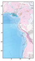
West Africa. These 20 giants (Fig. 5) occur
along the rifted margin formed by the opening of the South Atlantic Ocean. Rift history comprised a
Neocomian-to-Aptian period of continental rifting, with lacustrine or brackish sediments infilling
half-grabens. This was followed by an Albian-to-recent passive-margin phase, which was dominated by
landward-derived, prograded clastic-carbonate platforms, locally deformed by underlying salt deposits.6
The two stages are separated by formation of a large,
Aptian salt deposit along most of the West African margin. The salt deposit derived from evaporation of a
standing body of water formed by separation of the continents. This immense salt deposit formed an important
seal for hydrocarbons derived from the pre-rift section, as well as having created structural traps in the
overlying passive-margin section. Classification of these giants is difficult, since source rocks mainly occur
in pre-salt lacustrine units, while reservoirs occur mainly in carbonate rocks of the post-salt, marine
passive-margin section. The authors classified these giants as forming on a continental passive margin
fronting a major ocean basin.
| |
West Africa |
|
| |
43 |
Soku, Nigeria, Oil/gas/cnd |
|
| |
44 |
Krakama, Nigeria, Oil/gas |
|
| |
45 – 46 |
Bomu, Nigeria, Oil/gas/cnd |
|
| |
47 |
Imo River, Nigeria, Oil/gas/cnd |
|
| |
48 |
Kokori, Nigeria, Oil/gas/cnd |
|
| |
49 |
Cawthorne Channel, Nigeria,
Oil/gas/cnd |
|
| |
50 - 1 |
Obagi, Nigeria, Oil/gas/cnd |
|
| |
52 |
Jones Creek, Nigeria, Oil/gas/cnd |
|
| |
53 |
Nembe Creek, Nigeria, Oil/gas/cnd |
|
| |
54 |
Oso, Nigeria, Gas/cnd |
|
| |
55 |
Apoi North–Funiwa, Nigeria,
Oil/gas/cnd |
|
| |
56 |
Edop, Nigeria, Oil/gas |
|
| |
57 |
Amenam–Kpono, Nigeria,
Oil/gas/cnd |
|
| |
58 – 60 |
Okan, Nigeria, Oil/gas/cnd |
|
| |
61 |
Meren, Nigeria, Oil/gas |
|
| |
62 |
Ubit, Nigeria, Oil/gas |
|
| |
63 |
Forcados Yokri, Nigeria, Oil/gas/cnd |
|
| |
64 |
Rabi-Kounga, Gabon, Oil/gas/cnd |
|
| |
65 |
N’Kossa Marine, Congo
(Brazzaville), Oil/gas |
|
| |
66 |
Takula, Angola, Oil/gas |
|
|
|
|
 |
|
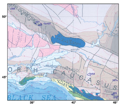
Black Sea. There are 10 giant fields in this
region, Fig 6. The Black Sea is a composite basin formed by rifting in the Aptian (western basin) and
Paleocene-Eocene (eastern basin) along the northern edge of Tethys. Source rocks range in age from Paleozoic
through Cenozoic, with dominantly Eocene reservoirs. Structures formed during the closure of Tethys and
include the inverted Dneiper-Donetsk rift to the north of the Black Sea.
| |
Black Sea |
|
| |
370 |
Starogroznyy, Russia, Oil/gas
(Caucasus) |
|
| |
387 |
Ozeksuat, Russia, Oil (Caucasus) |
|
| |
392 |
Prilukskoye (Dnepr), Ukraine,
Oil(Dneiper-Donetz) |
|
| |
423 |
Malgobek-Voznesensko-Ali-Y, Russia,
Oil/gas (Caucasus) |
|
| |
453 |
Stavropol’-Pelagiada Sever,
Russia, Gas (Caucasus) |
|
| |
481 |
Shebelinka, Ukraine, Gas/cnd
(Dneiper-Donetz) |
|
| |
485 |
Yefremovskoye, Ukraine, Gas/cnd
(Dneiper-Donetz) |
|
| |
499 |
Astrakhan’, Russia, Gas/cnd
(Caspian North) |
|
| |
527 |
Krestishchenskoye Zapadnoy, Ukraine,
Gas/cnd (Dneiper-Donetz) |
|
|
|
|
 |
|
Fig. 6. Black Sea region. |
|
Ural Mountains. This region (Fig. 7.) formed
the rifted eastern margin of Baltica during Ordovician-to-Permian time, with grabens forming major Paleozoic
depocenters in the basin. A foreland basin was superimposed on this margin during collision of the Ural arc
during the Late Permian to Early Jurassic. Structural trap formation occurred during this orogeny and created
the area’s 23 giants, which resulted in folds forming as far as 300 mi west of the Uralian deformation
front. Source rocks are traceable Devonian shales deposited during the early graben phase prior to collision.9
| |
Urals |
|
| |
372 |
Yarega (Yaregskoye), Russia, Oil
(Pechura) |
|
| |
373 |
Tuymazy, Russia, Oil/gas
(Volga-Ural) |
|
| |
374 – 80 |
Bavly, Russia, Oil/gas (Volga-Ural) |
|
| |
381 – 84 |
Romashkino, Russia, Oil/gas
(Volga-Ural) |
|
| |
385 |
Serafimovka, Russia, Oil/gas
(Volga-Ural) |
|
| |
386 |
Novo-Yelkhovka, Russia, Oil/gas
(Volga-Ural) |
|
| |
388 – 90 |
Mancharovo, Russia, Oil/gas
(Volga-Ural) |
|
| |
391 |
Arlan, Russia, Oil/gas (Volga-Ural) |
|
| |
401 |
Vozey, Russia, Oil/gas (Pechura) |
|
| |
404 |
Usa, Russia, Oil (Pechura) |
|
| |
414 |
Khar’yaga, Russia, Oil
(Pechura) |
|
| |
424 |
Mukhanovo, Russia, Oil/gas
(Volga-Ural) |
|
| |
425 |
Dmitriyevskoye (Samara), Russia,
Oil/gas (Volga-Ural) |
|
| |
426 |
Yarino-Kamennolozhskoye, Russia,
Oil/gas (Volga-Ural) |
|
| |
427 – 29 |
Pavlovskoye (Perm), Russia, Oil/gas
(Volga-Ural) |
|
| |
430 |
Kuleshovka, Russia, Oil/gas
(Volga-Ural) |
|
| |
451 |
Zhanazhol, Kazakstan, Oil/gas/cnd
(Ust Urt) |
|
| |
456 |
Orenburg, Russia, Gas/cnd/oil
(Caspian North) |
|
| |
472 |
Karachaganak, Kazakstan, Gas/cnd/oil
(Caspian North) |
|
| |
475 |
Layavozh (Layavozhskoye), Russia,
Gas/cnd/oil (Pechura) |
|
| |
483 |
Vuktyl (Vuktyl’skoye), Russia,
Gas/cnd/oil (Pechura) |
|
| |
531 – 33 |
Tolbazy, Russia, Oil/gas
(Volga-Ural) |
|
| |
534 |
Chutyr-Kiyengop, Russia, Oil/gas
(Volga-Ural) |
|
|
|
|
 |
|
Next Month
In Part 3, the six remaining areas where giants are
clustered will be discussed. These are: West Siberia; Siberia; China; Sundra; Western Australia; and Bass
Strait / Australia / Tasmania.

Literature
Cited
1 Klett, T. and J. Schmoker, "Changes
in observed field-size estimates of the world’s giant oil fields," Abstracts, p. A106, AAPG Annual
Convention, Denver, Colorado, June 3 – 6, 2001.
2 Halbouty, M., "Giant oil and gas
fields of the decade 1990 – 2000," Online published version http://www.searchanddiscovery.com
/documents. AAPG Annual Convention, Denver, Colorado, June 3 – 6, 2001.
3 Carmalt, S. W. and B. St. John, "Giant
oil and gas fields," in M. T. Halbouty, ed., Future petroleum Provinces of the World, Memoir, 40, AAPG,
Tulsa, Oklahoma, 1986.
4 Exxon Tectonic Map of the World, World
Mapping Project, Exxon Production Research Company, Houston, Texas, 1985.
5 Lewis, C., "Sarir field [Sirte
basin, Libya]," in Structural Traps II, compiled by N. Foster and E. Beaumont, AAPG Treatise of
Petroleum Geology, Atlas of Oil and Gas Fields, AAPG, Tulsa, Oklahoma, pp. 253 – 267, 1990.
6 Bandouy, S. and C. Legorjus, "Sendji
field – People’s Republic of Congo, Congo basin," in Structural Traps V, compiled by
N. Foster and E. Beaumont, AAPG Treatise of Petroleum Geology, Atlas of Oil and Gas Fields, AAPG, Tulsa,
Oklahoma, pp. 121-149, 1991.
7 Pierce, W., "Southern Arabian
basin oil habitat: Seals and gathering areas," Society of Petroleum Engineers, SPE25606, Bahrain Oil
Show, pp. 103 – 111, 1993.
8 Hall, S. and V. Sturrock, "Tectonic
control on the creation of supergiant fields in the central and south Caspian area," Houston
Geological Society Bulletin, Vol. 43, pp. 13 – 17, 2001.
9 Tull, S., "The diversity of
hydrocarbon habitat in Russia," Petroleum Geoscience, Vol. 3, pp. 315 – 325, 1997.
The authors |
 |
Paul Mann has
worked at the University of Texas Institute for Geophysics since 1983 and is currently a senior research
scientist there. He holds a PhD in geological sciences from the State University of New York at Albany. He
has held visiting professorships in New Zealand and France. Mann has done geological / geophysical
fieldwork throughout the Caribbean region, as well as participated on several research cruises offshore
New Zealand and in the Western Pacific. He invites comments at: paulm@ig.utexas.edu. |
|
Lisa Gahagan
has been project manager for PLATES, a global plate tectonic research project at the Institute for
Geophysics of The University of Texas at Austin, since its inception in 1991. She holds a master’s in
geological sciences from the University of Texas at Austin. |
|
Mark B. Gordon
has done geological research in Central America, Cuba, France and Saudi Arabia as a post-doctoral
scientist at Rice University and the University of Paris. He has been working at GX Technology since 1997
doing pre-stack depth seismic processing on basins throughout North America. He holds a PhD in geological
sciences from the University of Texas at Austin. |
| |
|
|