USGS estimates 53.8 Tcf of natural gas hydrates in Alaska’s North Slope
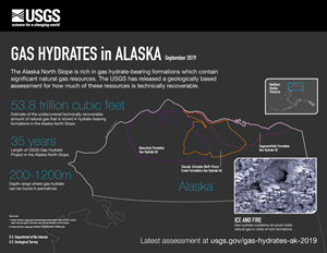
WASHINGTON - The Alaska North Slope contains an estimated 53.8 trillion cubic feet of natural gas hydrate resources, according to a new assessment by the U.S. Geological Survey. This estimate is for the undiscovered, technically recoverable natural gas resources stored within gas hydrate formations.
“The USGS is committed to providing the most up-to-date, publicly available, peer-reviewed estimates of the nation’s energy resources,” said Walter Guidroz, program coordinator for the USGS Energy Resources Program. “As more information becomes available, we sometimes need to revise our assessments to ensure they reflect the best available science.”
This assessment updates a 2008 USGS assessment that estimated about 85 trillion cubic feet of undiscovered, technically recoverable gas resources within gas hydrates on the Alaska North Slope. That assessment was the first-ever estimate of technically recoverable gas resources within gas hydrate.
The newly released 2018 gas hydrates assessment utilized more extensive 3D seismic mapping, improved data collection and more refined analysis. Access to better maps, as well as greater understanding of gas hydrate reservoir properties, allowed for more precise estimates. It is this refined analysis that yielded a smaller gas volume estimate in the 2018 assessment when compared to the 2008 assessment.
This assessment approach also assumes that the resource can be produced by existing conventional technology. To date, there is no known commercial production of natural gas from gas hydrate formation and the commercial viability of gas hydrate reservoirs is not yet known. This assumption is based on both limited field testing and numerical production models of gas hydrate-bearing reservoirs. No analysis was provided as to whether it would be profitable to produce these resources.

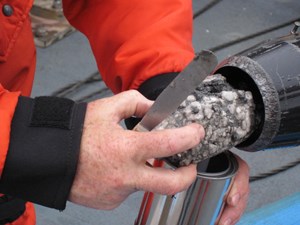
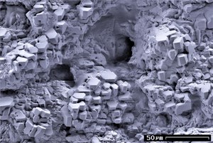
Gas hydrates are naturally occurring, ice-like solids in which water molecules trap gas molecules in a cage-like structure. They are only stable within a narrow range of temperatures and pressures and are usually found in seafloor sediments and in Arctic onshore permafrost environments.
Although many gases form hydrates in nature, methane hydrate is by far the most common, and there are thought to be significant natural gas resources contained in the world’s gas hydrate accumulations.
“The study of gas hydrate as an energy resource is still an emerging field,” said USGS scientist Tim Collett, lead author of the assessment. “The USGS has been conducting research on gas hydrates since the 1980s. Every time we conduct these assessments, we incorporate more and higher quality data, and our estimates become more precise.”
The USGS has studied the resource potential of gas hydrates for more than 35 years. Partnering with agencies like the Department of Energy, the Bureau of Land Management, the Bureau of Ocean Energy Management and Alaska state agencies, as well as international, industry and academic partners, the USGS has analyzed gas hydrate formations throughout the United States and around the world.

The USGS Gas Hydrates Project conducts multidisciplinary field studies, participates in national and international deep drilling expeditions, and maintains a laboratory program focused on hydrate-bearing sediments. In addition to the Alaska North Slope research, they have been participating in and sometimes managing large-scale drilling projects that investigate the resource potential of gas hydrate in Alaska, offshore India and the Gulf of Mexico.
The Gas Hydrates Project provides unique capabilities and special high-pressure laboratory facilities to study hydrate in conditions close to its natural state, producing the first assessment of technically recoverable gas hydrate resources; characterizing the physical properties of hydrate-bearing sediments to constrain reservoir properties; unraveling the possible synergies between gas hydrate breakdown and environmental change; and acquiring data to image the distribution of these deposits on the U.S. Atlantic, Gulf of Mexico and Beaufort Sea margins.


